About the Kidman Trail
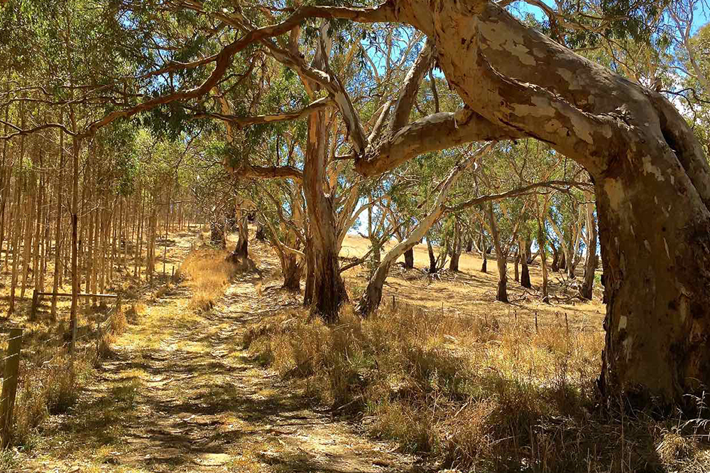
The KidmanTrail is a shared horse riding, cycling and walking trail located in the Mount Lofty Ranges of South Australia. It traverses 269 kilometres of roadsides, forest tracks, private land and unmade road reserves and highlights the natural beauty, cultural history and major points of interest as it passes through the Fleurieu Peninsula, Adelaide Hills, Murraylands and Barossa Valley tourism regions.
The trail is named after Sir Sidney Kidman, a prominent local pastoralist and horse breeder. Kidman was a pioneer of his time with unparalleled forethought in business and interminable community spirit.
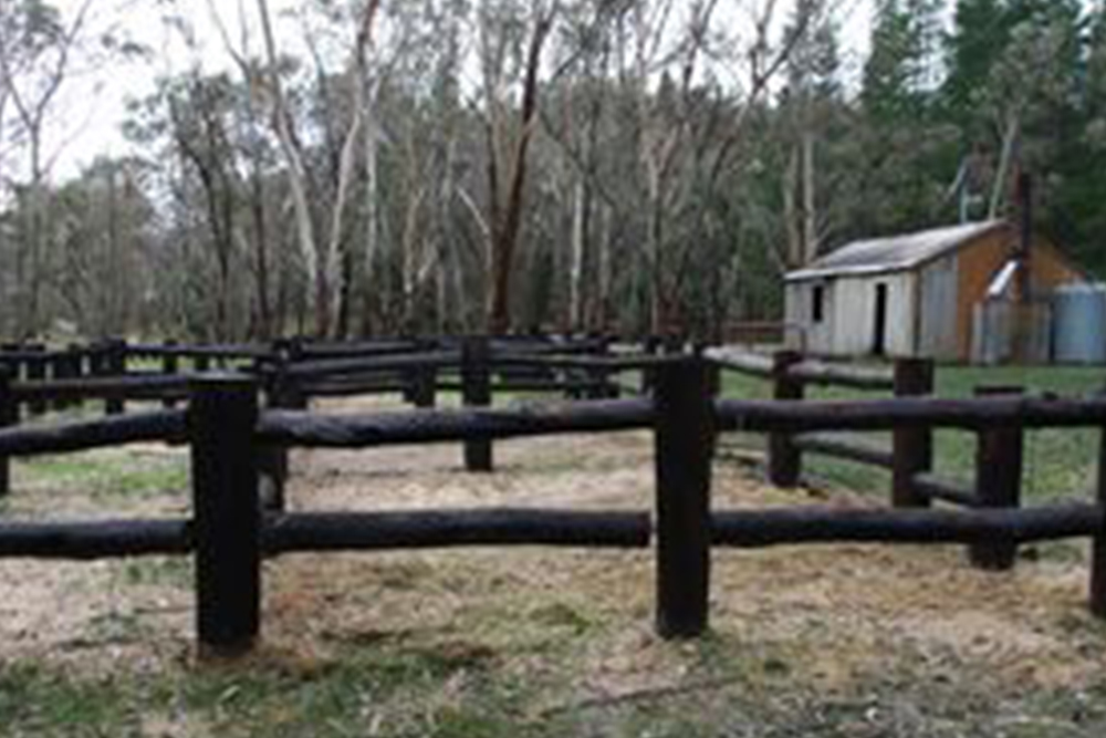
There are 11 trail heads along the route about a day’s horse ride apart that provide yards and water for horses. Most of these trail heads also provide the opportunity for trail users to camp at, with permission from the land manager of the site.
The Kidman Trail was designed as a horse riding trail, offering shared use experiences for mountain biking and bush walking. There are quite a few steep up and down hill sections and the route can be quite challenging after heavy rainfall along the sections of unmade tracks. However, the spectacular views, abundant wildlife, unique flora and the changing landscapes are most rewarding.
The 5 individual Kidman Trail maps are well annotated with history and sights along the way and each covering approximately 60 kilometres of trail. They show the Trail Heads, the typography and elevation for that section of the trail.
Kidman Trail Maps
The trail is divided into 5 map sections
- Map 1 Willunga to Echunga
- Map 2 Echunga to Nairne
- Map 3 Nairne to Mount Crawford
- Map 4 Mount Crawford to Stockwell
- Map 5 Stockwell to Kapunda
these are available as downloads from the Avenza Systems Inc. mapping app
The trail route can be viewed using the Location SA Viewer. Using the data search tool, search for Recreation Trails, hover over the trail routes to view.
Data.SA provides links to
- The Recreation Trails dataset
- A range of SA Government map viewers that may provide useful information for your planning.

Trail markers and Trailheads
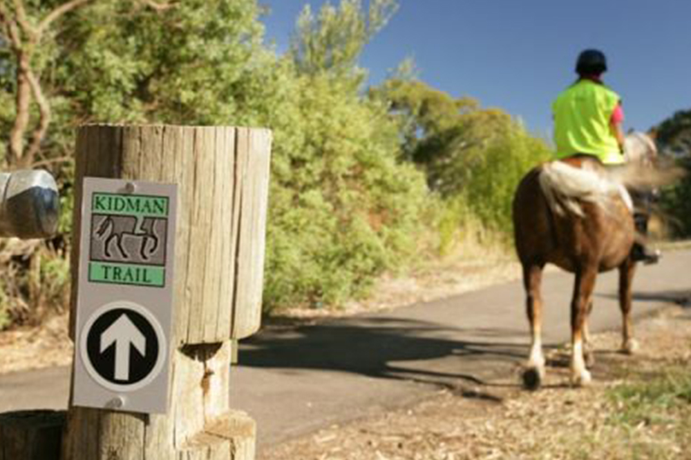
The trail is marked with 170mm x 74mm distinctive green and silver plates and a white directional arrow on a black background. Markers are generally attached to 90mm x 90mm CCA pine post but maybe attached to existing infrastructure such as stobie poles, street signs, fence posts and other trail posts where sections of the trail are also part of the Heysen and/or Mawson Trails.
The Kidman Trail has a minimalist system of marking with markers placed at decision points i.e. junctions and directional change. There are generally no additional markers installed between these points.
Trailhead signs are located at key locations along the trail and are linked to horse holding yards, horse water, and float parking. At most trailheads, Kidman Trail users can camp. This may involve pre-purchasing a camping permit and paying a camping fee.
Located at the end of Station Road, Willunga.
YARDS: 4 yards
WATER: Yes, tap behind building
CAMPING: No
CAMPFIRE: No.
FIRE BAN DISTRICT: Mt Lofty Ranges
FLOAT/TRAILER PARKING: Yes
TOILET: Yes, within walking distance in public park
HOW TO BOOK: No booking required for yards
Camping for people only, may be available at the adjacent Willunga Recreation Ground. Ph 08 8556 2407 Private facilities in the region are potentially available if you would like to camp with your horse. Contact Pam Brookman Mb 0429 888 002
Willunga to Jack’s Paddock 25.4kms
Located within Kuitpo Forest Reserve, ForestrySA.
A permit for horse riding and camping is required from ForestrySA. Riding permits can be obtained from
Ask the Ranger if there are any re routes in place.
Forests are closed on total fire ban days.
YARDS: 8 yards
WATER: Yes, tank water
CAMPING: Yes - Camping is allowed between 1 April to 30 November
CAMPFIRE: Yes – 1 May to 31 October. Gas fires allowed 1 to 30 November
FIRE BAN DISTRICT: Mt Lofty Ranges
FLOAT/TRAILER PARKING: Yes
TOILET: Yes
HOW TO BOOK: ForestrySA. Bookings are essential in advance. Fees will apply. Ph: (08) 8391 8800 to book Jacks Paddock
Jack’s Paddock to Echunga 25.1kms
Located in the old carpark of the Echunga Golf Course, within the Echunga Recreation Grounds, along the Aldgate-Strathalbyn Road
YARDS: 4 yards
WATER: Yes, tap by golf course fence
CAMPING: Yes (no shelter structure)
CAMPFIRE: No.
FIRE BAN DISTRICT: Mt Lofty Ranges
TOILET: not at site. 1/2km away at Echunga Hall
FLOAT/TRAILER PARKING: Yes
HOW TO BOOK: Online at Mount Barker Council. www.mountbarkercouncil.sa.gov.au. Go to Application Forms and Information, then scroll down to Camping Permit in Trail Heads Kidman Trail[Nairne, Echunga, Macclesfield] Mt Barker Council Ph 08 8391 7200
Council requires at least 10 working days in advance of your camping date.
Camping is free but must be registered with Council. Day time use of the yards is free, no bookings are required.
Echunga to Macclesfield 19.1kms
Corner of Walker Street & Magpie Lane, Macclesfield, Entry must be from Walker Street and not through the Macclesfield oval complex.
No horses are to access the Macclesfield oval complex outside of the Kidman Trail campsite without permission.
YARDS: 4 yards
WATER: Yes, tank water
CAMPING: Yes. Small 3 sided shelter
CAMPFIRE: No.
FIRE BAN DISTRICT: Mt Lofty Ranges
FLOAT/TRAILER PARKING: Yes. (Max. 4)
TOILET: Yes, located on the Macclesfield Oval & Sporting Complex
HOW TO BOOK: Online at Mount Barker Council. www.mountbarkercouncil.sa.gov.au. Go to Application Forms and Information, then scroll down to Camping Permit in Trail Heads Kidman Trail[Nairne, Echunga, Macclesfield] Mt Barker Council Ph 08 8391 7200
Council requires at least 10 working days in advance of your camping date.
Camping is free but must be registered with Council. Day time use of the yards is free, no bookings are required.
Macclesfield to Nairne 32kms
Corner of Sydney Road and Pyrites Road, Nairne
YARDS: 4 yards
WATER: Yes, tank water
CAMPING: Yes. No shelter structure.
CAMPFIRE: No.
FIRE BAN DISTRICT: Mt Lofty Ranges
FLOAT/TRAILER PARKING: Yes
TOILET: No. Toilets at Nairne Oval Complex approx. 600m away
HOW TO BOOK: Online at Mount Barker Council. www.mountbarkercouncil.sa.gov.au. Go to Application Forms and Information, then scroll down to Camping Permit in Trail Heads Kidman Trail[Nairne, Echunga, Macclesfield] Mt Barker Council Ph 08 8391 7200
Council requires at least 10 working days in advance of your camping date.
Camping is free but must be registered with Council. Day time use of the yards is free, no bookings are required.
Nairne to Rockleigh 32.6.kms
Rockleigh Road at the Old School house.
YARDS: 4 yards
WATER: Yes, tank water
CAMPING: Yes. Shelter available.
CAMPFIRE: Yes
FIRE BAN DISTRICT: Murraylands
FLOAT/TRAILER PARKING: Yes
TOILET: Yes (long drop)
HOW TO BOOK: Email Barbara Pym pymton1@bigpond.com to check availability for overnight camping and fees. No bookings required for day use.
Rockleigh to Mt Pleasant 30.9kms
Talunga Park, Melrose Street
YARDS: No dedicated yards, bring your own electric tape
WATER: Yes
CAMPING: Yes, No shelter
CAMPFIRE: Yes in a fire drum
FIRE BAN DISTRICT: Mt Lofty Ranges
FLOAT/TRAILER PARKING: Yes
TOILET: Yes
HOW TO BOOK: Talunga Recreation Park. Caretaker ph 08 85 681 934, Fees apply. Park under renovation in 2023.
Alternate accommodation Mt Pleasant Hotel Motel Ph 08 8568 2015
Some local B&B’s will also accommodate horses
Mt Pleasant to Ponderosa Hut 13.7kms
Mt Pleasant to Cowell Road 25.9kms
Starkey Road, Mt Crawford Forest
A ForestrySA permit for horse riding and camping is required. Riding permits can be obtained from www.forestrysa.com.au.
Ask the Ranger if there are any re routes in place.
Forests are closed on total fire ban days.
YARDS: 4 yards.
WATER: Yes, tank water
CAMPING: Yes, Camping is allowed from 1 April to 30 November. Large 3 sided shelter
CAMPFIRE: Yes – 1st May to 31st October. Gas fires allowed 1 to 30 November
FIRE BAN DISTRICT: Mt Lofty Ranges
FLOAT PARKING: Yes
TOILET: Yes
HOW TO BOOK: Forestry SA. Bookings are essential in advance. Ph: (08) 8391 8800 Fees will apply.
Ponderosa Hut to Cowell Road 12.2kms
100 Cowell Road Mt Crawford
YARDS: 4 yards
WATER: Yes. Horse water tap located inside toilet shed
CAMPING: Yes. Small 3 sided shelter
CAMPFIRE: Yes- outside of fire ban periods
FIRE BAN DISTRICT: Mt Lofty Ranges
FLOAT/TRAILER PARKING: Yes
TOILET: Yes, includes mobile phone charging point
HOW TO BOOK: Contact the Mt Crawford Dressage Club. Mb.0408 438 232.
Camping fees will apply.
Cowell Road to Rams Head Corner 27.7kms
Junction of Corks Hill Road, Pennys Road and Jutland Road
YARDS: No yards
WATER: No water
CAMPING: Yes.
CAMPFIRE: Yes.
FIRE BAN DISTRICT: Murraylands
FLOAT/TRAILER PARKING: Yes
TOILET: No.
HOW TO BOOK: No bookings required. Free.
Rams Head Corner to Stockwell 27.4kms
Currently no public trail head facilities at Stockwell. Private camping and horse yards available 1 km from Stockwell on Duck Ponds Road at the Schuberts property. Call Greg Ph 0412 739 396 for availability
FIRE BAN DISTRICT: Mt Lofty Ranges
Stockwell to Kapaunda 26.7 kms
41 Hancock Road, Kapunda at the Kapunda Harness Racing Club
YARDS: 4 yards have been constructed for Kidman Trail users. Other horse facilities available by arrangement
WATER: Yes by arrangement with Kapunda Harness Racing Club
CAMPING: Yes.
CAMPFIRE: Seek permission from the club
FIRE BAN DISTRICT: Mid North
TOILET: Yes
HOW TO BOOK: Kapunda Harness Racing Club. Fees may apply. Bookings: Club secretary Mb: 0428 956 462
Planning
By planning your trip on the Kidman Trail, regardless of if you intend to go alone, with a friend or as part of a larger group, you will lay the foundation for a successful and enjoyable experience. Not all sections may suit all types of riders or their horses, all cyclists and all bush walkers. Check the trail maps carefully so you are aware of the distances and elevations that you need to traverse. Horse riders must obtain a permit from ForestrySA to ride through the sections of the trail that traverse Forestry land and all users need to obtain permission/permits and where required pay a camping fee for the overnight camping at the trail heads.
The Kidman Trail is open all year round, however from December to March it can be very hot and the trail sections through ForestrySA land are closed on fire ban days. Mid-June to mid-September can be very wet and cold, but still enjoyable, if you are appropriately prepared for the weather conditions. Check forecasts daily for the sections you are planning to traverse.
If you are planning to travel the Kidman Trail you will need to organise transport from where you are planning to start to where you are planning to end.
Walkers and cyclists can check out local transport operator websites for current services, costs, timetables, bike transport and bookings.
Horse riders will need to organise private transport for both them and their horses. If you are not taking a pack horse or carrying all your and your horse’s needs on your riding horse, it is quite easy to do a float shuffle daily from one trail head to the next if there are at least two of you riding. Alternately you could ask family or friends to move your float on to your next campsite.
All trail users should carry enough drinking water for their daily needs which will be dependent on the amount of effort and distance they travel and the weather. Water in creeks, water holes, on the ground or in stock troughs should never be drunk. Trail heads have stock water but no potable water. Some trail heads are a considerable distance from towns where supplies can be topped up so it may be necessary to do water drops ahead of time or have backup support. In hot weather horses may require a drink before reaching the trail head. Carry a foldable bucket so you can give them a drink if you find a suitable water source the horses cannot safely physically get to.
Cyclists refer to the advice given for preparation of your bicycle, the gear you require and your fitness for safe travel on the Mawson Trail.
Walkers refer to advice given for preparation of your gear and your fitness for safe travel on the Heysen Trail.
Training and fitness conditioning is essential before attempting the Kidman Trail. The horse needs to be able to cope with traffic, including walkers with back packs on, bicycles, motor bikes, cars, trucks and large farm machinery, all of which can be legally on sections of the trail and often do not understand the nature of horses. They also need to cope with step overs, creek crossings, narrow bridges, uneven and wet surfaces, kangaroos, koalas, deer and general farm livestock with minimum of fuss.
Most of the trail will be done at the walk, with each day taking between four and seven hours of riding time, therefore it is important to do several training rides for that length of time to check your saddle fits and you and your horse do not get sore.
Horses will need to be shod or booted for a lot of the trail as many sections are on gravel roads.
Plan to have teeth checks, vaccinations, worming, chiropractic, body work and any other veterinary treatment required well before the ride and shoeing close to when you leave.
Horses prefer to travel and camp with at least one other horse. If you planning to go with only one horse, make sure it does not become anxious by itself before going.
Although mostly walking, horses require a significant degree of fitness to cope with the terrain which includes some steep ascents and descents. They become fitter over time but it is very important to build a good degree of fitness before starting and be prepared to have some rest days if your horse becomes tired.
It is very beneficial to the horse [and you] if you can get off and lead the horse for periods throughout the day.
Feed will need to be brought in by a backup vehicle, or local feed stores may deliver to some trail heads, as there is insufficient grazing to sustain horses along the trail or at the trail heads.
Generally, just feed what you normally do at home and maybe add an extra kilogram or two of concentrated feed a few days into the trip, but only on the days you are actually riding.
Water for horses is available at all the trail heads but you will need a suitable water bucket.
Trail heads have at least 4 overnight holding yards, but if you are planning on erecting your own yards or hobbling or night lining your horse, practice these techniques to make sure your horse is safe and contained by them.
Make sure you are capable and confident to manage your horse in the situations you will likely encounter on the trail that are listed in the above section ‘Your horse’ .
Acquire the maps and carry them in a form that you can refer to along the trail.
Acquire all permits before you go. Some require at least 10 working days’ notice.
Make sure you have an understanding of both human and horse first aid, plus carry a suitable first aid kit.
Carry a list of phone numbers of vets along the trail with you.
There is phone reception along a lot of the trail, but there are sections with no reception. Carrying a small PLB [personal locator beacon] is advisable.
Backup crew should have a set of maps. Work out, at the start of each day’s ride, what happens if either of you have a problem meeting your expected travel times.
It is best to travel in a group of at least three, in case of an accident/emergency.
Let someone know your daily ride plans.
Have in mind an exit/contingency plan if you find it too difficult or unsafe to continue.
Horse equipment must be in good condition, comfortable for the horse and checked daily for any damage.
The horse needs to be checked daily to ensure they are not sore or lame and are fit to continue travelling on the trail.
Carry suitable equipment to tie a horse up if required.
Try to take as little gear as possible with you riding, but include lunch and snacks, drinking water, sunscreen, emergency first aid kit, mobile phone with back crew’s and vet’s numbers, camera and your maps plus your wet weather gear and an extra hoof boot.
Leave camp early as this gives both you and your horse more time to relax, eat and sleep at the end of the day, plus more daylight hours if you have a problem.
It is advisable to wear an Australian safety approved helmet and bright reflective clothing when riding
Our Venues | Office for Recreation, Sport and Racing (orsr.sa.gov.au)
Recreation and Trails | Office for Recreation, Sport and Racing (orsr.sa.gov.au)
Bureau of Meteorology (bom.gov.au)
Visitor Information Centres | South Australian Tourism | South Au...
Plan a South Australian trip | SA Tourism | South Australia
Department for Environment and Water - Home
Bicycle SA - Home (bikesa.asn.au)
Outback Odyssey | Bicycle SA (bikesa.asn.au)
Melrose Mountain Bike Trails - Melrose MTB
The Friends of the Heysen Trail
Accommodation along the Heysen Trail
Walking SA | Find a Place to Walk or a Hiking Club | South Australia
Paddling Trails South Australia - Paddling Trails South Australia
Considerations
Keep horses out of the main human camp area for safety and hygiene.
Regularly check on the horses during the night.
Insects bothering horses cause extra stamping and damage. Pack repellent to assist in managing this.
If horses dig up or disturb the soil, level it out again.
Well-fed contented horses do little damage. Nervous or bored horses with excessive pawing may require hobbles.
Use taps or water sources provided. Carry a collapsible bucket of water so you can carry water to the horse. Avoid damaging creek banks, dam walls or other natural water supplies that may occur if you take a horse to water.
Carry or use processed horse feed eg extruded or heat treated pelleted feed
Select feeds that will not allow weeds to germinate from any spilled or uneaten meals.
Replace rocks and other items you may have shifted for your use.
Re-cover loose dirt and paw holes, this prevents filling with water or wind damage, which will then commence the erosion process.
Remove all spilled waste, litter or leftover food including eggshells and cigarette butts.
Manure needs to be removed into sacks and taken away by the back up vehicle or placed in containers if provided. If the above methods are not possible, scatter discreetly (not around native trees, which suffer easily from nutrient overload) well away from watercourses and camping areas.
Any uneaten feed, including weed-free hays, should be collected up and disposed of thoughtfully. It is litter to others trail users!
Plan meals to have little or no left overs
Remove excess packaging from food and other items before packing for the ride.
Garbage needs to be disposed of in provided bins or taken out of the campsite with you.
People ride to enjoy the environment and their horses. Other trail users may cycle or walk, but also want to get outdoors and enjoy the natural landscape. Leaving what you find, how you found it applies to Cultural heritage – both Indigenous and European along with the Natural heritage – avoid collecting plants or other specimens.
Plant diseases, such as Phytophthora (PC) may be found in regions where the Kidman Trail passes through.
Good practice when leaving home (if you have PC near your normal riding areas at home), leaving each campsite or before returning home is to:
Clean out hooves and mud off of boots and car wheels and spray with disinfectant
Check horse boots, bandages or long fetlock feathers which may contain foreign seeds and remove and destroy
Observe fire ban periods
Observe any particular Local Council or ForestrySA by-laws relating to sites or seasons for campfires
Check if campfires are permitted at the campsite you intend to use
Use a gas stove, for cooking
Bring your own wood for the campsites which permit fires
Use an established fire-ring
Take your rubbish with you.
Saturate the left over ash with water and make sure it is cool to touch before leaving
Stay on the marked trail
Riding in pairs on wide sections of the trail
Single tracks or narrow trails should be ridden in single file and in the centre of the track
Stay on the trail, even through deeper mud, unless it is a safety issue, to avoid making detour trails
When taking breaks, move off the trail onto a durable surface to allow other trail users to pass safely
Encounters and observations of native wildlife greatly enhance the trail users experience Observe from a distance, take only photographs and travel quietly.
Do not feed animals or birds. Pack away all food securely at night
Trail use is increasing in popularity, especially in the peri-urban areas to Adelaide through which the Kidman Trail is marked.
Access problems should be reported to the relevant land manager or use the facebook group, South Australian Trail Reporter.
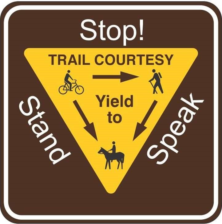
Assist other trail users to pass you, many walkers and cyclists are afraid of horses.
Talk to other trail users. All efforts to create a better understanding and appreciation of how different user groups can share the trail will benefit us all.
Leave gates open or shut as you find them.
Ride quietly past any farm stock.
Bike Riders:
- slow down when passing other trail users, or stop and allow them to pass you
- alert others when approaching from behind
- be aware horses may be scared of bikes
Walkers:
- keep to the left where possible
- keep dogs on leash (2 metres or less) and be mindful of other users passing
- be mindful of others approaching from behind
- to protect vegetation, avoid walking off trail
- be aware many horses are frightened by walkers with back packs on
Runners:
- keep to the left where appropriate
- be mindful of other users behind you
- alert other users when approaching from behind
- be prepared to slow or stop when approaching horses
Horse riders:
- horses have right of way over other trail users
- alert walkers when approaching from behind
- advise other trail users the safest way to pass